Predictive ecological models for 39 climax and subclimax habitats were built based on the Hungarian Actual Habitat Database (MÉTA). Environmental predictors were, among others, the fine-resolution, downscaled climate and soil data.
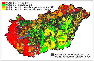
A research conducted by the researchers of the MTA Centre for Ecological Research resulted in the multiple potential natural vegetation map of Hungary. Predictive ecological models for 39 climax and subclimax habitats were built based on the Hungarian Actual Habitat Database (MÉTA). Environmental predictors were, among others, the fine-resolution, downscaled climate (CarpatClim-Hu database) and soil (DOSoReMI.hu database) data. The trained models can predict the probability of occurrence of the habitats.
Due to their high resource-intensity (both processor and memory), computations related to statistical downscaling climate data (Regression Kriging) and training correlative ecological models (Boosted Regression Trees) were done in the virtual server of EcoInfLab, using R statistical software in Ubuntu Linux environment.
Monthly mean, minimum and maximum temperatures, monthly precipitations of the period 1977-2006, i.e. a total of 48 data vectors, were downscaled at the resolution of the MÉTA database (i.e. at a hexagonal grid with 734 m distance).
The article is published in the Journal of Vegetation Science and can be requested here. While the results of the research are available for researchers in the resolution of MÉTA database, low-resolution maps are downloadable to those interested in.
Citation:
Imelda Somodi, Zsolt Molnár, Bálint Czúcz, Ákos Bede-Fazekas, János Bölöni, László Pásztor, Annamária Laborczi, Niklaus E. Zimmermann (2017): Implementation and application of Multiple Potential Natural Vegetation models – a case study of Hungary. Journal of Vegetation Science. DOI: 10.1111/jvs.12564